|
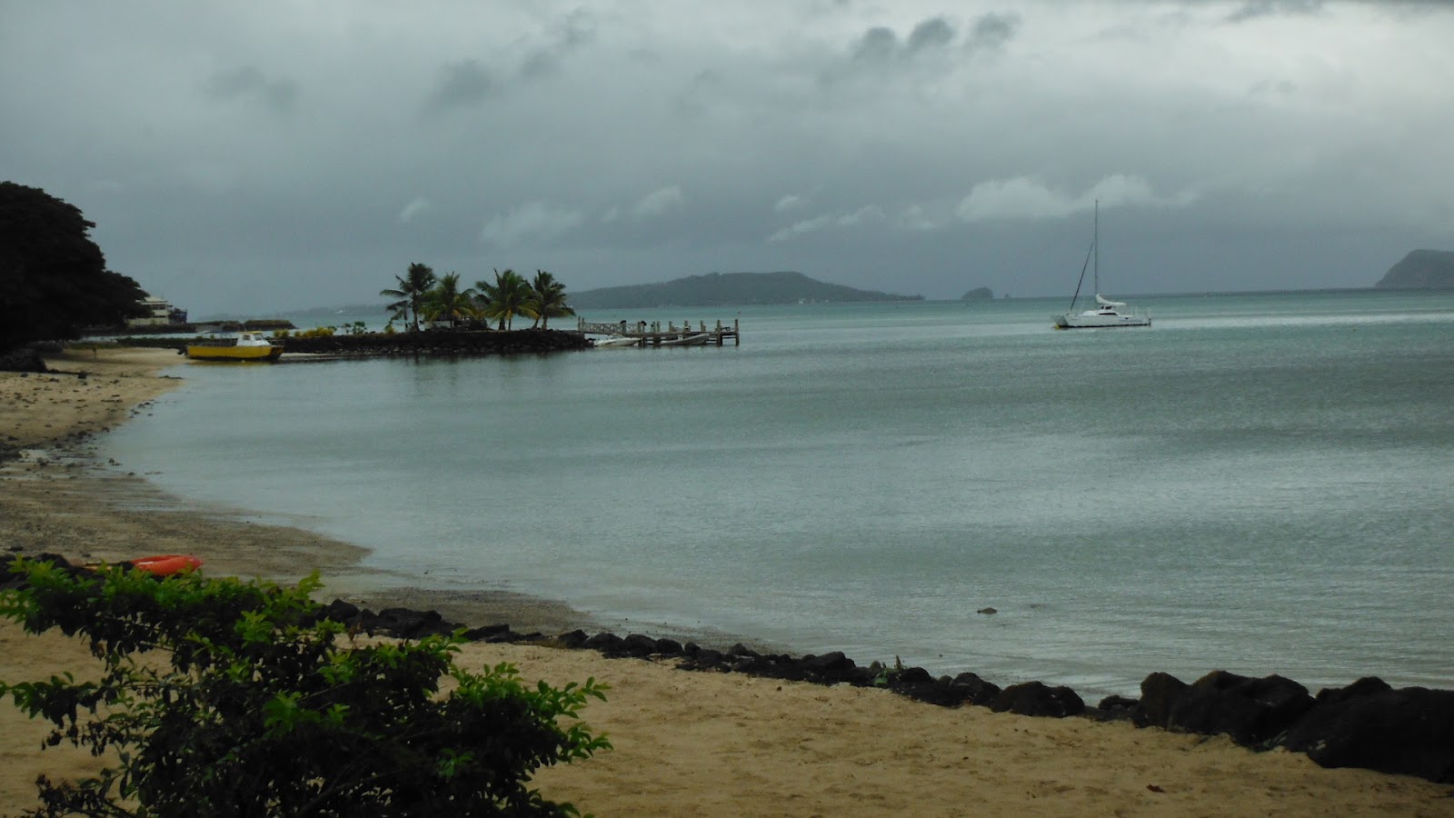
| Entering Queen Charlotte Sound, South Island |
Chapter Three: South Island
 |
| One of the Southern Alps |
The ferry crossing to the South Island is a two to six hour
adventure, depending on the sea and the weather. We made it in about four, with
pretty heavy swells moving one of us to seasickness for a while. The ships for
this trip are large—lots of cars, big trucks, campers and RVs. Once they get you parked inside the
ship, you find a seat near the bar, food court or lounge or stand on one of the
decks.
The Cook Strait was pretty rough until you get in the
“shadow” of the South Island, then things flatten out a bit. Then once you get into Queen Charlotte
Sound, it might as well be a lake.
Since we caught a sunny, bright morning for this trip, we had
spectacular viewing—just cold and windy.
The boat finally docked and we headed south down the Pacific coast to
Christchurch, the most English city in NZ.
 |
| The girls slept through this one. |
The road cuts through one of NZ’s best know wine producing
areas, then some hills and more sheep before heading along the actual coastline—all
in sight of the Southern Alps, the snow covered monsters that seem to have just
sprouted out of the pastures and vineyards. NZ is one of the Earth newest landforms and the mountains
are vertical, jagged and rocky—like the Grand Teton in Wyoming, only the range
is the length of the island and almost always in view.
The Pacific was raging and roaring just like the Tasman had
been on the other side two days before, big white-capped waves crashing noisily
on the beaches. The driving was
slow and hard since the road hugged the coastline. It would have been fun to drive in Gail’s car, but this big
old SUV doesn’t handle like a Beetle convertible, so we plodded along, stopped
for lunch at a place with a view and then headed into Canterbury, of which
Christchurch is the provincial capital.
 |
| South of Queenstown |
Earthquakes devastated Christchurch in recent years and most
of the downtown was destroyed or damaged to the point where you can’t see
anything of the city center. We stayed on the outskirts of the town and walked
a few blocks to a mall and a restaurant.
We passed churches and pubs that showed the damage. In fact, the churches seemed to be the
places that showed the most damage, maybe the 19th century stone
construction did not allow for the elasticity necessary to stay upright in an earthquake. In any case, we’ll
not be adding this one to the retirement list; the next morning was once again
cold and sunny as we headed toward Mt. Cook.
The drive was up, over and through the foothills and
plateaus leading up to a couple alpine lakes and finally, NZ’s tallest
mountain. The mountain and its
brothers block the west end of a glacier-created lake, and were framed by our
motel room windows.
 |
| At the foot of Mt. Cook |
We were right
at the base of the range and so close you could walk over and start climbing. Actually, it’s maybe a mile away, but
since the air was so clear and cold, it looked really close. We scraped off the frost from the
windshield the next morning and headed down the valley and around the lake
toward our main South Island destination—Te Anau and Milford Sound.
Milford Sound is one of the fiords that the ice ages cut
into the southwest corner of the South Island, and spectacularly green,
vertical and beautiful, but the drive there is pretty spectacular itself. We rolled past several glaciated lakes
and lots more sheep before we got into the higher, ice and snow-covered part of
the trip (“allow two hours, check road conditions, rent chains from the service
station if needed”). We took
longer to get there, but didn’t need the chains after we checked. We were told to beware of the black
ice.
 |
| Early Morning Mt. Cook |
 |
| The Road to Milford Sound |
The drive started out in clouds and fog—it was hard to tell
which we were driving through any particular moment—then moved up into Alpine
forest, lakes and the snow. The NZ
highway people had conveniently spread some kind of “grit” limestone chat, I
guess, on the roads provide us with traction on ice, but I thought it just made
the road slipperier.
 |
| Still on the Road to Milford Sound |
We came
across waterfalls, icefalls, roaring mountain streams, incredible ice cycles
and, of course one-lane bridges.
We even drove through a one-lane tunnel for at least a kilometer
downhill, ending in a sharp curve that lead to more sharp switchbacks and
curves down to the Sound. Just
before we arrived, we were stopped by the friendly NZ highway department man
who told us to “drive very slowly the last 10 kilometers or so, because they
hadn’t put down the morning grit yet and filling out the insurance forms for
our wrecked rental car would be sooo time-consuming”.
 |
| The Sound |
But nothing ill befell us and we landed safe and sound at
the Milford Sound boat harbor and got ready to board. As with everywhere else in NZ, people thought we were a
little odd: two obviously Chinese girls with a couple really white people. And since we were surrounded by Chinese
tourists, we sort of stuck out.
The Sound was incredible…waterfalls, dolphins, seals, bright
blue sky and sea and yes rainbows…well, sunny waterfalls that created rainbows. It was all majestic and magical and
unchanged from 30 years ago. The
boat took us out just into the Tasman Sea, turned around and came back on the shadow
side of the Sound, stopping to let waterfalls spray us. Dolphins followed us, and seals slept
on the rocks.
 |
| Wood Family in Winter |
We drove back up through the tunnel, past the ice cycles and
fog/cloud and lakes to get back to Te Anau in time to take another water excursion
with a boat-load of Chinese tourists, enjoying the glowworms in a cave on the
opposite shore of Lake Te Anau.
The cave itself is pretty long and requires SCUBA equipment and
wetsuits. The tourist trip we took
is a brief walk into the cave and a silent, totally dark boat ride into a
grotto, where the worms glow from the ceiling of the cave.
 |
| Pancake Rocks National Park |
After Milford Sound, it was a four-day hustling drive back up
to Auckland, touching every possible one-lane bridge on the way. We should have counted them. We came up
the Tasman coast of the South Island, stopping for the night near the Franz
Joseph Glacier, then continuing on to Picton the next evening. On the way, we stopped to visit the
Pancake Rocks Blowholes—curious rock formations, but only blowing at high tide
and we had just missed that.
The 7:00 AM ferry the next morning was delayed five hours
and we finally landed in Wellington after 3:00 PM, then drove five hard hours
to Napier, a curious little city on the Pacific coast of the North Island. Napier’s town center was pretty much
destroyed by an earthquake in the 1930s then rebuilt in an Art Deco fashion. It was all cute and pretty but we had
to head on to Auckland for the flight the next day. Napier might be added to
the list, but isn’t as spectacular as Wellington or Waikere.
 |
| Giant Fruit of Cromwell |
We arrived in time to find a movie theater in a mall and saw
The Amazing Spiderman, our last tourist event of the trip. The next day we turned in the car at the airport, and with the luggage properly weighed and wearing our winter
clothes, boarded the plane for Fiji.
 |
| Somewhere on the South Island |
 |
| The Long White Cloud |